Garmin Montana 700i Rugged GPS Touchscreen Navigator with inReach Satellite Communicator (010-02347-10)
Product details
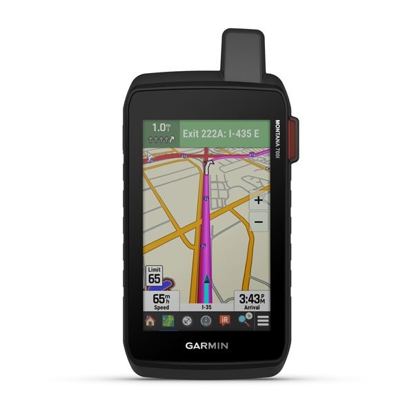
Stay in touch and on track with Montana 700i. This rugged GPS handheld combines TopoActive and City Navigator mapping for routable on- or off-road navigation with global two-way messaging and interactive SOS via inReach satellite technology (active satellite subscription required; some jurisdictions regulate or prohibit the use of satellite communications devices). The 5” color touchscreen features a full QWERTY keyboard for messaging and a display that’s 50% larger than earlier models. Multi-GNSS support and sensors for the 3-axis compass and barometric altimeter put a world of outdoor navigation capability within your grasp. Plus, wireless pro-connectivity gives you direct-to-device access to BirdsEye Satellite Imagery downloads, location sharing, Connect IQ app support and more. Pair with a compatible smartphone to access Active Weather forecasts. Extend battery life for more than a week with the new ultralow-powered Expedition mode. For hunters and trainers, the IPX7-rated unit syncs with compatible Astro or Alpha series handhelds (sold separately) to help track sporting dogs in the field.
GO INTO THE WILD WITH A SATELLITE CONNECTION
• To keep adventurers in touch and on track, the Montana 700i handheld combines the flexibility of on- or off-road navigation with global messaging and interactive
• SOS via inReach satellite technology
• Big news. A full QWERTY keyboard lets you easily type messages.
• Wander wider and still stay in touch — with inReach for messaging and 24/7 SOS.
• Routable topographic maps? Check. Now you’re free to take it off-road or on.
• Built like a tank. Meets MIL-STD 810 for thermal, shock, water and vibration.
• Get the clear perspective of BirdsEye Satellite Imagery right to your device.
• Power your adventures with 18+ hours of lithium-ion battery life in GPS mode.
• Link up from way out — with inReach technology.
TWO-WAY MESSAGING
• Exchange text messages with loved ones, post to social media, or communicate via inReach device to inReach device in the field (active satellite subscription required ).
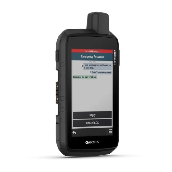
INTERACTIVE SOS
• In case of emergency, trigger an interactive SOS message to GEOS, a professional 24/7 global monitoring and response center (active satellite subscription required ).
GLOBAL CONNECTIVITY
• Instead of relying on cellphone coverage, now your messages, SOS and tracking are transferred via the 100% global Iridium® satellite network (active satellite subscription required ).
INREACH WEATHER
• Available inReach weather forecast service provides detailed updates directly to your Montana handheld or paired devices, so you’ll know what to expect en route.
• Be prepared. With navigation for any situation.
RUGGED BY DESIGN
• This durable, water-resistant handheld is tested to U.S. military standards and features a glove-friendly 5” touchscreen that’s 50% larger than previous Montana models.
CITY NAVIGATOR MAPS
• Seamlessly transition from trails to road navigation with preloaded City Navigator street mapping, which guides your drive with easy-to-follow turn-by-turn directions.
TOPOACTIVE MAPS
• To navigate your adventures, use preloaded topographical maps for the U.S. and Canada. View terrain contours, elevations, coastlines, rivers, landmarks and more.
PUBLIC LAND BOUNDARIES
• Optional display of federal public land boundaries on topographical maps helps you know that you’re venturing where you’re supposed to be.
SATELLITE VIEWS
• Use direct-to-device downloads of BirdsEye Satellite Imagery (no annual subscription required) to see photo-realistic views and create waypoints based on landmarks.
ABC SENSORS
• Navigate your next trail with ABC sensors, including an altimeter for elevation data, barometer to monitor weather and 3-axis electronic compass.
ACTIVE WEATHER
• Use cellular connectivity to access up-to-date Active Weather forecasts through the Garmin Connect™ app .
DOG TRACKING
• For hunters and trainers, this Montana syncs with compatible Astro ® or Alpha ® series handhelds (sold separately) to help track sporting dogs in the field.
MULTI-GNSS SUPPORT
• Access to both GPS and Galileo satellite networks enables Montana 700i to track in more challenging environments than GPS alone.
TRACKING
• Using your web-based MapShare™ trip-sharing page, followers can see your progress, ping your device to see your GPS location and exchange messages during
your trip.
EXPEDITION MODE
• Trek far and wide off-grid. Use Expedition mode, an ultralow-power GPS reference, to keep Montana tracking for a week or more between recharges.
EXTENDED BATTERY LIFE
• An internal, rechargeable lithium-ion battery pack provides more than 18 hours of battery life in GPS mode.
VEHICLE MOUNTS
• A variety of Montana handheld-compatible mounts (sold separately) lets you adapt your navigator for use on ATVs, boats, cars, motorcycles, RVs or other
vehicles.
Specifications:
• PHYSICAL DIMENSIONS: 3.6" x 7.2" x 1.3" (9.19 x 18.30 x 3.27 cm)
• TOUCHSCREEN DISPLAY SIZE 2.55"W x 4.25"H (6.48 x 10.80 cm); 5" diag (12.70 cm)
• DISPLAY RESOLUTION 480 x 800 pixels
• DISPLAY TYPE WVGA transflective, dual orientation
• WEIGHT 14.5 oz (410 g) with included lithium-ion battery pack
• BATTERY TYPE rechargeable lithium-ion (included)
• BATTERY LIFE
• GPS Mode: up to 18 hours
• GPS Mode, 10 min Tracking: up to 18 hours
• Expedition Mode: up to 330 hours
• Expedition Mode, 30 min Tracking: up to 300 hours
• WATER RATING IPX7
Add your review
Review Garmin Montana 700i Rugged GPS Touchscreen Navigator with inReach Satellite Communicator (010-02347-10)